Trail Walking La Bresse - Le lac des corbeaux et la roche du lac - Photo

Le lac des corbeaux et la roche du lac

« L’heure de la fin des découvertes ne sonne jamais. » Colette GUIDE+

© OpenStreetMap contributors
Length
Length
3 km
Max alt
Max alt
1121 m
Uphill gradient
Uphill gradient
225 m
Km-Effort
Km-Effort  
6 km
Min alt
Min alt
891 m
Downhill gradient
Downhill gradient
223 m
Boucle
Boucle
Yes
Creation date :
2021-12-22 11:58:04.718
Updated on :
2022-01-20 10:22:58.864

(0 Reviews)

Walking
Walking
1h22
Difficulty : Medium

Scan this QR Code to open this trail in the SityTrail application

FREE GPS app for hiking

Logo SityTrail SityTrail

IGN / Geographical institutes

Download SityTrail from the App Store Download SityTrail from Google Play

Logo SityTrail SityTrail World

The world is yours!

Download SityTrail from the App Store Download SityTrail from Google Play Download SityTrail on Huawei AppGallery

About

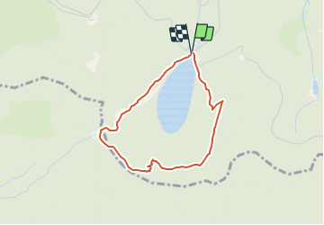
Trail Walking of 3 km to be discovered at Grand Est, Vosges, La Bresse. This trail is proposed by Au fil de nos découvertes.

Description

🅿️ Départ et Parking:
26, Route des Bouchaux
88250 La Bresse (France)

▶️ Suivre la balise « anneau jaune «
🥾 Prévoir de bonnes chaussures de marche.

Il est possible de faire le tour du lac (1 petit km)
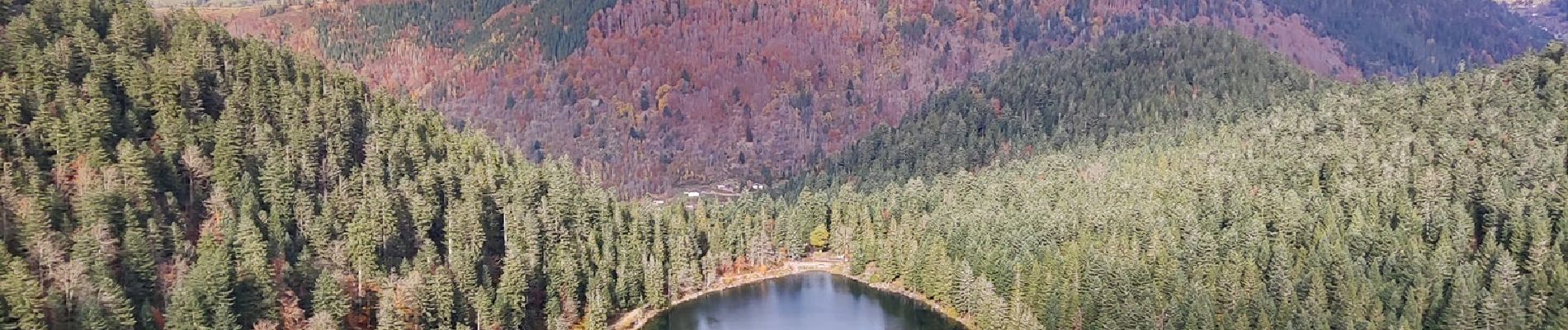
🌲🌳

Une bonne petite grimpette s’impose pour rejoindre le point de vue. 😱
Mais ça en vaut vraiment la peine.
Le chemin pour accéder à la roche du lac est très joli. 🥰
Pour le retour, vous reviendrez par le collet Mansuy.
Vous terminerez par le tour du lac.
⚠️ Attention, par temps pluvieux, les chemins sont très glissants.

Possibilités de pique-niquer. 🥪🍴
Chiens autorisés en laisse. 🐩🐶🐕
Convient pour les grands enfants. 👱👱‍♂️
Ne convient pas pour les poussettes et personnes à mobilité réduite. 👨‍🦽👩‍🦽👶

N'hésitez pas à aller faire un tour sur notre site internet et nos réseaux :
www.aufildenosdecouvertes.com
www.facebook.com/aufildenosdecouvertes
https://www.instagram.com/au_fil_de_nos_decouvertes/

Elevation profile

Photos

Positioning

Country:
France
Region :
Grand Est
Department/Province :
Vosges
Municipality :
La Bresse
Location:
Unknown
Start:(UTM)
343775 ; 5317706 (32T) N.

Trails nearby

Trail Walking La Bresse - 2023-04-15 Marche Abri Collet de Etang vers Abri Lac de Blanchemer - Photo
Walking
GUIDE
holtzv

Walking

Medium
(1)
La Bresse, Grand Est, Vosges, France
22 km | 35 km-effort
7h 51min
No
Trail Walking Wildenstein - 2022-02-20 Marche Kruth Grand Ventron - Photo
Walking
GUIDE
holtzv

Walking

Very difficult
(1)
Wildenstein, Grand Est, Haut-Rhin, France
16.8 km | 27 km-effort
4h 52min
Yes
Trail Walking Wildenstein - TREK ALSACIEN (boucle de Wildenstein) - Photo
Walking
Godasses et Grosses Pattes

Walking

Difficult
(1)
Wildenstein, Grand Est, Haut-Rhin, France
15.4 km | 24 km-effort
5h 20min
Yes
Trail Walking La Bresse - la bresse - le moutier des fées  - Photo
Walking
GUIDE
stef789

Walking

Very easy
(1)
La Bresse, Grand Est, Vosges, France
26 km | 36 km-effort
3h 26min
No
Trail Walking La Bresse - Autour du Lac des Corbeaux - Photo
Walking
Alfredy

Walking

Medium
(1)
La Bresse, Grand Est, Vosges, France
3.1 km | 6 km-effort
1h 30min
Yes
Trail Walking Wildenstein - Col du Bramont - Machey - Blanchemer - Photo
Walking
VacheKiri67

Walking

Medium
(1)
Wildenstein, Grand Est, Haut-Rhin, France
15.3 km | 22 km-effort
4h 27min
Yes
Trail Walking La Bresse - Le Couchetat - Photo
Walking
fedinois1

Walking

Very easy
(2)
La Bresse, Grand Est, Vosges, France
4.8 km | 7.4 km-effort
1h 50min
Yes
Trail Walking Cornimont - Xoulces _ Grand Ventron _ Vieille Montagne - Photo
Walking
jeanclaude12

Walking

Medium
(1)
Cornimont, Grand Est, Vosges, France
15.6 km | 25 km-effort
5h 6min
No
Trail Mountain bike La Bresse - randonnée découverte à la Bresse.  - Photo
Mountain bike
Dutyrider

Mountain bike

Easy
(1)
La Bresse, Grand Est, Vosges, France
30 km | 41 km-effort
2h 58min
Yes


Close
My subscriptions